Trimble GPS Systems: Solutions for Surveyors’ Needs
Trimble GPS Systems for surveying are of the highest quality and something you can rely on. When it comes to surveying, having precise and highly accurate data is a top priority. Those are the fields in which Trimble GPS systems excel.
Highest production quality standards for GIS professional
The mapping and the surveying community were the first ones actually to take advantage of the GPS. The GPS offered a dramatic increase in productivity and reliability when it comes to collecting data. All around the world now, GPS is a key feature in surveying and mapping methods.
In the hands of professionals, GPS guarantees to provide highly accurate surveying and mapping data. Of course, one more prerequisite for a high level of accuracy is a reliable GPS. Moreover, we want to assure you there are no systems more accurate and dependable than Trimble GPS systems.
GPS-based data gathering and collection is way faster when compared to traditional mapping and surveying techniques. In addition to added responsiveness, GPS in surveying reduces the amount of labor and equipment required. Only one surveyor can now accomplish in one day what once took a whole team week to do.
History of Trimble
 Four decades ago, in 1978, Charlie Trimble founded his company in Silicon Valley. Little did he know that doing this meant creating an entirely new industry. Right from its roots, Trimble was aiming to develop innovative navigation and positioning products.
The company started doing that with the help of LORAN tech. Loran was a ground-based location and timing system in the coastal waters of the United States. Luckily enough, the same year when the Trimble finds was launching the first GPS satellite, the NavStar.
Once the GPS space-based location system has complete, it included 24 satellites. That way, it was finally possible to address every single point on this planet with magnificent precision. Charlie Trimble and his co-founders saw that as the biggest and the most ambitious opportunity to expand their business using this innovative technology.
Therefore, Charlie Trimble invested in spreading the power of GPS through innovative, groundbreaking products. Moreover, thanks to him, GPS was applied to traditional, commercial markets such as navigation and surveying, which completely redefined them.
GPS Explained
The US Department of Defense was the one to develop and maintain the Global Positioning System. The GPS utilizes the satellites as points of reference to calculate positions precisely. Think of it as a way of giving every single corner of this planet its unique address. Nowadays, GPS use in construction equipment, airplanes, cars, and even laptops!
GPS in Surveying
Although GPS was once the system for military use only, now it’s a crucial part of our daily lives. GPS has become important in surveying, which is going to be our main topic today.
Surveying stands for the process of analyzing and recording characteristics of the land to create a map or a construction plan. Since GPS allows you to precisely see the position, including longitude, latitude, and height parameters, without requiring the measurement of distances and angles between points, it’s the perfect tool for surveying!
Hence, the only thing required for surveying with a GPS is a clear view of the sky. That way, it will be possible to receive the signal from the satellites.
We’re not going to go into details of the calculation process and the overall equipment, as these are pretty complex. However, we’re going to go over the user process, which is rather simple.
Essentially, in the available receiver, the GPS receiver quickly detects its position from the data broadcast by the orbiting satellites. The data that users receive include a precise description of the orbiting satellites and transmitting data.
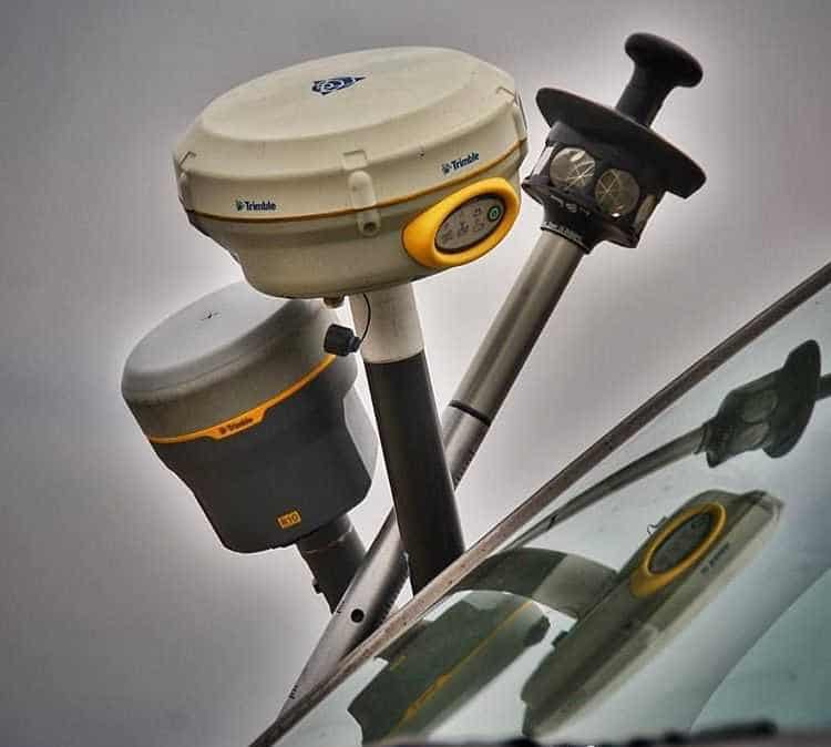
There are no systems as good as Trimble GPS systems when it comes to the precision equipment for surveying, civil engineering, and construction markets. There’s no need to go on and on about Trimble GPS systems, as their quality speaks for itself. It’s safe to say that Trimble helped revolutionize the industry of surveying and mapping.
How Trimble GPS Systems in Surveying Works
The GPS receivers that we use in our everyday lives are way inferior to those that we use in surveying. Surveyors use two different frequencies that are broadcast by the orbiting satellites.
The first is the phase or the physical characteristics of the GPS signal. Moreover, the other one is the highly sophisticated calculation technique, thanks to which it’s possible to obtain the most accurate data. Typically, these receivers need to have a separate antenna.
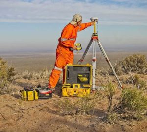
 A GPS baseline utilizes two receivers, where one at each end of the line needs to be measured. The data collect simultaneously. The duration of these observations is generally one hour or longer, depending on the required accuracy and the line’s length.
Special software has the task of calculating the difference in position between two points—this calculation base on longitude, latitude, and height.
Potential distortions in the observations coming from both sides of the baseline are quite similar to each other. This similarity enables the minimization of uncertainties of GPS positioning, as the distortions cancel each other out.
The ends of the GPS baseline can be very far apart from each other. We’re talking about thousands of kilometers in length. Still, they can observe the same satellites due to their high orbit position.
Additional GPS baselines are often measured to check the results and the uncertainty of the calculation. This method is not necessary, though, since we can easily determine the position of each baseline. We can do so just by knowing the position of a single baseline.
Types of GPS Used in Surveying
1. Kinematic GPS
If we limit the distance to around 20 kilometers, we can obtain a similar accuracy while using a receiver that is not stationary. This receiver moves between points and remains at each one of them for just a couple of seconds. The receiver on the base station immediately transmits corrections of the data to the remote station.
It only takes a few seconds to compute and store the position of the remote station. Due to this short time span, you can transmit the corrections via mobile phones or radios.
2. GPS Real-Time Baseline Measurements (CORS)
If we talk about major engineering projects or local government projects, the best thing is to opt for a permanent installation of the base station. All you need is a convenient location and a survey-quality GPS receiver. This method goes by the name of Continuously Operating Reference Station.
You can store collected CORS’ observations and correct them in the office afterward. In addition to that, you can access the CORS data and correct observations in real-time by using GPS instruments with built-in internet access.
Global observation generally uses CORS data. This way, the GPS becomes more reliable and accurate. A long list of countries that use the CORS network. Some scientific studies use this type of network if it’s geologically stable. The observations have to be continuous and measure for a long period.
Example of CORS in Australia
 CORS networks cover the most populated areas of Australia. Subscribers can usually access the data in real-time, thanks to commercial providers. You can also access the data freely through the highly accurate, national CORS network.
There’s a regional GPS network in Australia that one can use with the online processing system. GPS data from a survey-quality receiver is submitted through the internet thanks to this method.
To calculate the positions, they use more accurate satellite orbits. That way, they can provide a position with a negligible uncertainty of just a few centimeters.
Other than longitude and latitude, GPS also measures height due to its three-dimensional system. There are three different surface levels to measure to calculate the height:
The mean sea level
The ellipsoidal height
Moreover, the geoid level
The difference in height between the first two levels can go up to 100 meters. Also, this difference can vary based on the different densities of the earth. Luckily enough, the experts have found a way of understanding this difference. That’s why the majority of GPS software applies it routinely.
That’s where the geoid level steps in. Even though some tend to consider these three levels the same for most practical purposes, when you want the highest accuracy in the application, you have to take them into account.
Surveying and Trimble
 As we’ve mentioned earlier, Trimble is unrivaled when it comes to surveying with the help of a GPS. In fact, with the added Trimble 3D scanner, around 2003, Trimble’s surveying market was enriched with the innovational positioning tech.
Only a year after that, with the addition of GeoNav’s software expertise, resources, and software, Trimble introduced fully customizable solutions to the market.
Over the years, Trimble has partnered with many large companies, Include Geomatics Land Surveying, which led to them further improving and advancing in the industry. That was also the case when Trimble acquired the assets of a Hungarian company, GeoDesy and GeoDesy FSO, in 2014. GeoDesy was manufacturing and distributing accessories intended for surveying tools.
These tools consisted of tripods, prism poles, adapters, robotics, mapping, and GNSS systems. Need More Information About Trimble GPS Equipment? Read This Article
Top 5 Trimble GPS for Land Surveying for Every Surveyor
[…] the land surveying industry, precision and reliability are paramount. Many GPS systems help with surveying, but Trimble is a leader. They offer different models for specific project […]