Trimble Surveying Equipment: The Best Tools for Mapping and Surveying

Trimble Surveying Equipment is the best for Mapping and surveying, especially with the growth of technology in these areas. Over time, the industry has grown to include cutting-edge technology, such as total station robotics, laser scanners, data collectors, 3D, and digital capabilities, and more.
About Trimble Surveying Equipment
Trimble has been at the forefront of that progression, widening its product line from traditional Trimble surveying equipment to the Trimble Laser Scanner, GPS systems, and both today’s and tomorrow’s cutting-edge additive
The name Trimble Surveying Equipment has become synonymous with leading-edge design, ease of use, effic, science, and health for the construction world and beyond nts, Trimble has used to change surveying with all of the exciting evolvements game, which technologies are considered the best?
A product must have the ability to operate efficiently, increase a user’s or site’s productivity and provide a team with an improved data collection workflow. The following tools have all of this and rank highest on our lits.
Trimble Surveying Equipment has been used to change the surveying with all of the exciting evolvementsgame. Which technologies are considered the best? A product must have the ability to operate efficiently, increase a user’s or site’s productivity and provide a team with an improved data collection workflow. The following tools have all of this and more and rank highest on our list.
3D Laser Scanning
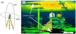
There’s a need for precision — and then there’s a need for advanced precision in a whole other dimension for a comprehensive result. Enter Trimble’s laser scanning line, which can offer speed and versatility: critical elements for any scanning professional.
The cream of the crop for Trimble’s 3D products is the SX10, which is truly the ultimate all-in-one system. It can collect any combination of high-density 3D scan data along with its enhanced VISION imaging and high-accuracy total station data to give a user exactly the information they need when they need it.
Want to have access to a full dome panorama? No problem with the SX10; it can have one captured and ready in as little as three minutes. Using Trimble’s advanced Lightning 3DM, which allows for dense scan data at high speeds, it will incorporate precise total station measurements and true high-speed 3D scans and turn around impressive measurement performance … all in one single instrument.
Adding to the Trimble SX10’s capability arsenal is its ability to adjust a scan level density for specific project needs. Registration is automatic when the survey workflow is used, and all of the information required for that project — augmenting survey data for specific areas of interest, dome scans and more — will be gathered and integrated into the coordinate survey system.
The top applications for the Trimble SX10 are roadways/corridors; topographic surveys and general surveys; infrastructure as-built projects; volumetric surveys, building as-built projects; and utility design surveys.
The units are fully integrated with familiar workflows of Trimble Access and Trimble Business Center software, and they can deliver scanning speeds of up to 26,600 Hz at ranges up to 600 meters and the smallest spot size in the industry: a mere 14 mm at 100 m.
Mobile Mapping

It used to be that no mapping or surveying work was possible without some element of manual labor — and in many cases, that labor was extensive and performed in conditions that were anything but pleasant or easy access. Not so anymore, especially with the advent of Trimble’s mobile mapping technology.
With these vehicle-mounted mobile spatial imaging systems, a project can bring together its georeferencing with ultra-precise and high-speed laser scanning and high-resolution imaging sensors. Trimble’s portfolio in this area includes the MX9, MX7, and Mx2 — each with its unique features for a myriad of uses.
At the forefront is the MX9, considered a complete field-to-finish solution that combines advanced hardware with intuitive field software with reliable, efficient office software workflow. Mounted on top of a veh, it will collect dense point clouds and images rapidly, both multi-angle and panoramic.
Don’t worry — even at highway speeds, the MX9 is working and providing rich data, which has a significant impact on data collection even when working a busy highway (in other words, no more costly lane closures).
The ideal applications for the Trimble MX9 include road assets, cross-sections, GIS layers, 3D models, elevation models, and volumetric analyses. It is compatible with existing Trimble software and workflows and has enhanced remote support capabilities with the lightest, most compact premium mobile mapping system.