Everything you need to know about Trimble GPS Equipment
Trimble GPS Equipment is known to play a vital role in our lives by helping us commute from one place to another. But today, the technology is no longer about just aiding in commuting and is also being used in construction sites.
Transforming Industrial Surveying Tools
Trimble GPS Equipment is extremely beneficial in providing accuracy and dependability, especially for the site surveyors. The crew no longer has to rely on conventional surveying equipment for collecting data. Using a GPS device makes the job simpler as the data collected is accurate and quick. Trimble GPS Equipment today is one of the best used in the construction sector worldwide. Their cutting-edge technology allows users to analyze complex information in no time and make productive decisions.
Provide contractors with construction solutions
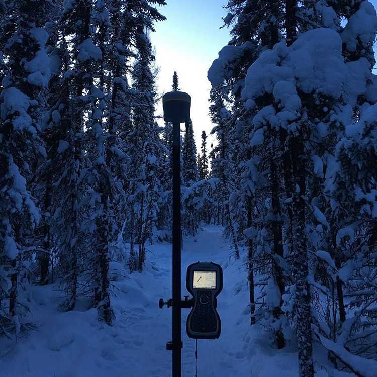
 Trimble is a leading provider of precision equipment for the surveying, construction, and civil engineering markets. The Trimble GPS Equipment is designed to aid in high-efficiency surveying to the workers in extreme environments.
Some of the major GPS of the Trimble GPS systems include seamless integration with other technologies, precision, scalability, accuracy, and efficient after-sales service. Today the Trimble GPS systems are being efficiently used in more than 150 countries. It is courtesy of the efficient network of employees, dealers, and distributors around the world.
We at Geomatics Land Surveying are proud to be one of the largest distributors of Trimble GPS systems. Through exemplary services and support, we have built a reputation throughout the industry of mapping and surveying. We deal in an array of products in the category of Trimble GPS systems. The below article has reviews about some of the top picks.
Advantages of Using Trimble GPS Surveying Equipment
Trimble offers survey solutions that make use of cutting-edge technology and improve the efficiency of the land surveyors. Each of their product is designed to understand the surveyor’s needs, like their workflow and the kind of data integration they require.
The Trimble GPS systems can aid in improving your surveying equipment and helping you collect accurate location data. Some of the advantages of using Trimble surveying solutions include;
- Each of their equipment is designed in adherence to high-quality standards. They provide high accuracy precision through the sub-centimeter accuracy in measurements.
- The products are continuously updated every year to remain up to date and integrate with the workflow of the surveyor.
- The Trimble systems aid the surveyors to work in the most challenging environments providing a high level of accuracy in the measurements.
- Another advantage of the Trimble GPS Systems is their speed.
- By making use of some of the best cutting-edge technology that can shorten the project time frames. Compared to the traditional surveying methods, these help your work faster and complete projects in shorter time frames.
- The technology used in the Trimble products enables you to survey larger tracts of land and longer distances with much efficiency.
- The equipment is designed with broader functionality and can also help you save in the long run. With the high accuracy Trimble equipment, you require smaller human resources to complete large-scale projects. Hence this enables you to save considerably on the workforce cost. Savings on human resources directly relates to more profit.
- Apart from these, the Trimble systems allow the surveyors to increase their overall productivity by improving the accuracy of data collection.
- The Trimble GPS systems provide perfect coordination between the field and the office helping deliver timely final output to the client.
Have a Construction Project? Trimble GPS Equipment is Your Answer.
Here is the best Trimble GPS Equipment Products List for surveying:
1. Trimble R10 ($9,500.00) – An Integrated GNSS System
 Integrated powerful technologies and sleek design make the Trimble R10 a favorite product amongst land surveyors. Specifications of the system that make it a top choice include a max precision of 8 mm H / 15 mm V. Also, it has an integrated antenna and 672 channels.
The R10 can receive and transmit UHF Radio. The system is aiding the surveyors to collect data with accuracy, thereby increasing their productivity every day. Some of the important features of the Trimble GPS include;
- If you experience connection outages from the RTK base station, the Trimble will provide continuous coverage and comparatively lesser downtime in the field.
- It comes with a combination of Trimble 360 technology and a powerful 672 channel solution promising advanced satellite tracking.
- Another key feature is the integrated wireless communications. It aids you in sending and receive corrections and documents from the field.
- It comprises HD-GNSS, which, compared to the traditional GNSS technology, provides more accuracy in assessing errors. As a surveyor, When facing challenging environments, technology is beneficial.
- The Trimble Sure Point ensures you measure the otherwise inaccessible points with accuracy.
- It comes with a very ergonomic design that is compact and lightweight. The design ensures both easy handling and operation.
Using the Trimble R10 GNSS System, the surveyors can now access the inaccessible points effectively and make faster and safer measurements.
2. Trimble R8s ($8,200.00)
 The Trimble R8s is a popular device with surveyors and is known for its flexibility and scalability.
Trimble R8s gives you the flexibility of building a tailor-made system as per the requirement. Also, it can adapt to the changing environments as well in the future.
All you need to do is add to the required functionality. Some of the salient features of the receiver include;
- The receiver is highly scalable, and one can configure the same as per future needs.
- It is designed with Trimble 360 receiver technology that provides an advanced satellite tracking system. Also, there are 6 Trimble Maxwell chips present that includes 440 channels.
- It includes the Trimble DL Android app that aids in collecting the GNSS raw data for post-processing.
- It seamlessly integrated with the Trimble S-Series Total Stations and provided rover only, base, rover, and base configurations.
- With R8 GNSS, there are two radio options available, one is the UHF radio, and the other is the GSM cellular modems.
Overall with the Trimble R8s, it is more like configuring the receiver today and achieve scalability tomorrow. It comes with a max precision of 8 mm H / 15 mm V.
3. Trimble R2 GNSS Receiver ($4,500.00)
 The Trimble R2 GNSS Receiver is an ideal product for both who are involved in surveying as well as mapping.
Trimble R2 GNSS Receiver:industry-leading with GNSS functionality provides many configurable options to deal with particular market demands for both Mapping and research customers.
TRIMBLE R2 IS A DURABLE GNSS RECEIVER TO COLLECT HIGHLY ACCURATE
Some of the important features of the system include,
- The equipment has a max precision of 10 mm H / 20 mm V and helps measure highly accurate data.
- It comes with a Trimble Maxwell 6 chip comprising of 220 channels that helps maximize data quality.
- The system is quite easy to use and set up, helping you focus on work and maximize productivity.
- The Trimble R2 easily pairs with devices like your smartphone, Trimble handhelds, or tablets.
- It provides accurate data by supporting multiple satellite constellations. Also, it provides submeter and centimeter positioning accuracy.
The Trimble R2 receiver provides complete flexibility and gives you the leverage to choose solutions based on accuracy. A major USP of the Trimble R2 receiver is that it is quite compact and durable.
4. Trimble R1 ($1,995.00)
 The Trimble R1 is another lightweight compact and rugged GNSS receiver system that provides accurate position information to the land surveyors.
The receiver is quite useful for the mapping and GIS professionals in any organization.
Trimble R1 GNSS Receiver designed for GIS data collection, asset management and integrates seamlessly with your iOS or Android device
Some of the striking features of the system include the following;
- They can connect to any mobile device through Bluetooth technology and deliver location data with higher accuracy.
- The list of compatible devices with the Trimble R1 includes consumer-grade smart devices like smartphones, tablets, and Trimble handheld data collectors. Hence one can say that it gives you complete flexibility in choosing your data collection device.
- It comprises optimal viewpoint RTX that gives you a precise submeter accuracy. You can achieve this either through satellite or IP.
- The Trimble R1 system with 50cm max precision, 44 channels, and an integrated antenna help you collect professional-grade positioning information.
5. Trimble Geo 7X ($6,666.00)
 Trimble Geo 7X is a popular Trimble handheld GPS that belongs to the family of high accuracy handhelds. One of the major GPS of the handheld device is that it provides 1-100 cm GNSS accuracy.
The other important features of the handheld device include
- A rugged device that provides high accuracy data and is extremely useful in organizations like municipalities, utility companies, and various other environmental agencies or assets management solutions.
- It comes with a 10.7 cm screen size, providing a more accurate and better viewing experience.
- Designed with WEHH 6.5 operating system, the device makes geospatial data collection easy and accurate.
- The handheld device also has remote positioning capability for greater productivity.
- The system is compatible with satellite systems like Galileo, QZSS GPS, GLONASS, and BeiDou.
- Overall we can say that the device is quick and cost-effectively provides accuracy. The field and office software truly enhance productivity even in the most challenging circumstances.
We at Geomatics Land Surveying also have used Trimble GPS equipment for sale. You get hold of some amazing devices loaded with features at affordable prices.
Incorporating GPS Systems With The Total Stations

Using GPS for land surveying includes incorporating the technology into a Total Station to produce the survey data. Now, what exactly is a Total Station? Surveying equipment made by integrating electronic theodolite and distance meter. These aid in measuring distance up to a particular spot from the instrument.
The efficiency of this equipment increases when coupled with other technologies like GPS systems. They form a total package that aids in land measurement and mapping.
The data obtained by using such total stations are more accurate than those obtained using the traditional methods. The need for trigonometry and triangulation is completely negated as the electro-optical scanning ensures high degree accuracy.
Coupled with GPS technology, the Total Stations ensure that unseen points are also measured during the survey.
Using this equipment increases productivity and efficiency by many folds. Also, you can save on workforce as only one surveyor is required in the field, unlike two required in the past with conventional equipment.
The total stations also are provided with image capture technology, which means surveyors can obtain images directly from the survey site. The extra costs of site revisits are reduced drastically as the high-resolution images of the site are available at your disposal.
Finally, the total stations produce electronic documentation, which means they can be used with devices like computer systems and applications like mapping software. Most of the total stations available today are robotic, which means they need to come back to the total station frequently to make any measurement changes.
Three Types of GPS Measurements

1. Static GPS Baseline: It is one of the primary methods of GPS-based measurements that many surveyors utilize. The system is widely used in the determination of accurate coordinates for survey points. It is accomplished by recording GPS observations between known and unknown points for 20 minutes.
The data thus obtained is processed in the office, and the coordinates are obtained. The accuracy of the measurements depends upon the duration of the observations. For a 1km baseline, the accuracy is about ±1 ppm, while for 10kms it is ± 5 mm + 1 ppm).
2. Time Kinematic (RTK) Observations: This type of measurement involves one receiver located at the known point while the other transits within points. The former call the base station, while the later is called the rover station. The position of the later determines by using a radio link that provides coordinate correction.
The measurement type is incorporated in applications that require high accuracy measurements. It is used for centimeter-level positioning and can measure up to 1 cm + 1 ppm with accuracy. The technique enhances the accuracy of the GPS signal because a fixed base station is used to send corrections to the receiver. This further enables the GPS engine to fix the position of the antenna. Inside 10 km of the base station, the method provides similar accuracy to static baseline measurements.
3. Continuously Operating Reference Stations (CORS): Unlike the other two types of measurement methods, this involves the receiver being permanently installed in a location. It serves as the starting point for the GPS measurements to be carried out in the district.
The data collected from the surveyor’s GPS receivers are then used with CORS data to calculate the final positions. The measurement method is majorly put to use in places like mining sites and other major government and private engineering projects.
Conclusion-GPS and Land Surveying

In general, people have the notion that land surveys only mean marking boundaries of a property. But in reality, they are more than that as there are different types of land surveys used in different industries. Other than the land surveys for properties, another major area used is on the construction sites.
Today they have become one of the rapidly growing areas of land surveying. One of the significant tools that aid in land surveying today is the GPS.
Today, there are many companies in the market that provide GPS solutions for land surveying in the construction industry. But the brand that stands out in the lot is Trimble.
For quite some time now, the brand has been leading in the business providing high accuracy and quality. Other than the GPS systems, they have other flagship products as well that aid in land survey. Their equipment and software are dependable enough and help you make a mark with precision.
The first commercial use of the GPS systems was for surveying and mapping. It provides high accuracy data of longitude and latitude positions. Also, unlike the conventional measurement systems with the GPS-enabled ones, the need for measuring distances and angles between points is not there. Compared to the traditional surveying equipment, the results obtained by GPS-enabled survey equipment are highly accurate and fast.
Since the turnaround time for data collection is shorter, this subsequently reduces the decision-making time as well. The GPS technology involved in survey equipment also reduces the time taken to complete the job and labor costs. Using them, only a single surveyor can complete the job. Also, another advantage of GPS surveying is the visibility is not affected by weather conditions.
Today, GPS systems have found widespread use amongst surveyors, but it is equally important to understand that they have not fully replaced conventional equipment yet. Challenging environments like the ones near tall buildings and trees restrict the use of GPS systems as the connectivity with the satellites is hampered.
Although famous for GPS systems, the company manufactures products associated with other industries as well. The list includes agriculture, transportation, asset tracking, mobile resource management, and many more. Their portfolio includes more than 1200 patents and offering some of the best positioning technologies in the industry.
Top 5 Trimble GPS for Land Surveying for Every Surveyor
[…] technology. Since then, their GPS systems have become synonymous with precision and reliability. Trimble GPS systems offer the following key […]